Geology, Geologic Timeline, Geography
The North and South Yamhill Rivers form the Yamhill River at McMinnville.
It is an older, meandering river system that has cut its way deeply into the fertile soil of the valley floor, revealing a cross section of recent Oregon geologic history stretching back more than 50,000 years.
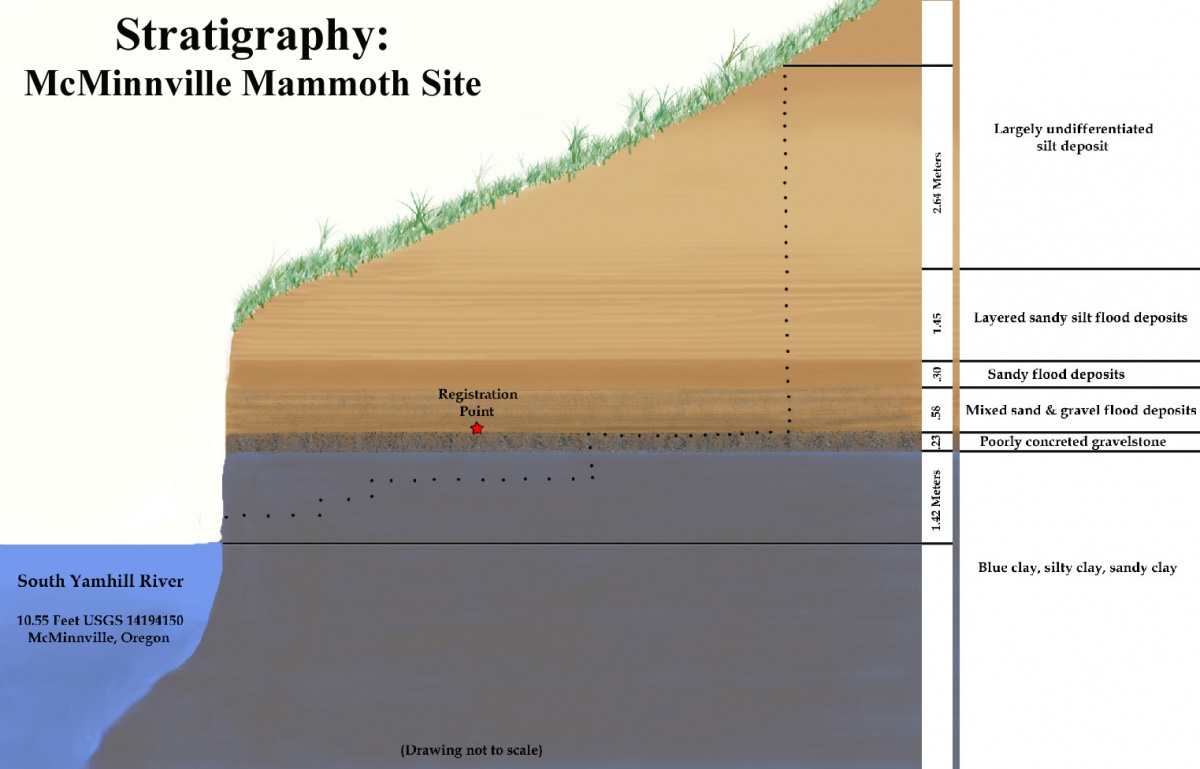
The geologic history of the late Pleistocene and early Holocene are revealed in the banks of the river like the pages in a book. A preliminary soil gradient study at the McMinnville Mammoth Site, currently radiocarbon dated at greater than 51,700 years, shows this area to be underlain by a thick deposit of variated blue clay, quite pure in places, silty or sandy in others; indicating a low energy water environment, possibly slow river, pools, ponding or a small shallow lake.
A layer of poorly sorted and poorly concreted gravelstone overlays and cuts into this deposit, and is believed to be river bottom gravel indicating an earlier channel of the Yamhill or Willamette river system. This in turn is overlain by more poorly sorted gravel which gives way to layers of sand and silt (again poorly sorted) believed to indicate further, lower-energy flood events, possibly the result of the Bretz or Missoula floods backing up the Willamette Valley. The entire area finally gives way to sandy-silty layers indicating possibly annual flood events. At the McMinnville Mammoth and Bison Sites, the entire site is overlain by the remains of a recent bank slump, a modern erosional event which is evidenced as a heavy layer of undifferentiated silt and visual remnants of a large slump block cut from the bank above the site.
The unravelling of the geologic story awaits us developing a resource much more knowledgeable in sedimentation and stratigraphy than we are to help us with the project and integrating several sites into a comprehensive study.
The late Pleistocene and early Holocene deposits revealed by the river’s constant erosional process are rich in glacial erratics.
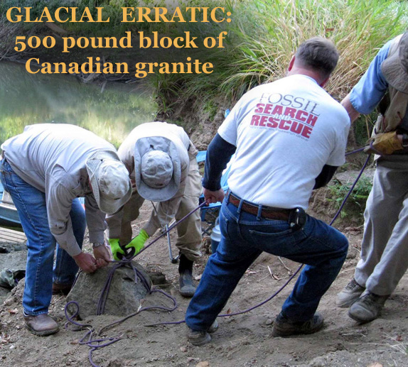
Glacial erratics, geologic specimens that have been transported to our area by the Bretz flood events, come in all shapes and sizes, from a multi-ton boulder sitting on a hillside between McMinnville and Sheridan to small quartzite pebbles shining on the river bottom.
Erratic Rock State Natural Site lies mid-way between Sheridan and McMinnville off Highway 18. At thirty eight tons, the boulder is the largest glacial erratic rock in the Willamette Valley. Transported here probably attached to an iceberg during the Bretz (Missoula) Flood events, the rock is argillite and believed to be 600,000 million years old. It is also the only rock of its type outside of Canada.
We located and then lost to a massive bank slump a large boulder on the bottom of the South Yamhill River believed to be a glacial erratic; but have recovered fine specimens of granite and schist, gneiss, some marble, quartzite and petrified wood.
In terms of Geologic Timeline, the 40,000 years compromising the focus of the project is less than the blink of an eye, yet in that time the vast herds of mega-fauna roaming the North American continent suffered a wave of extinctions. Gone are the mammoth, mastodon, giant ground sloth, species of bison, the horse and the camel and many more. Gone as well are many of the super predators that preyed on them: the short faced bear, American lion, saber toothed cat and dire wolf among others. Paleontologists ask why and look for answers in the Yamhill River basin.
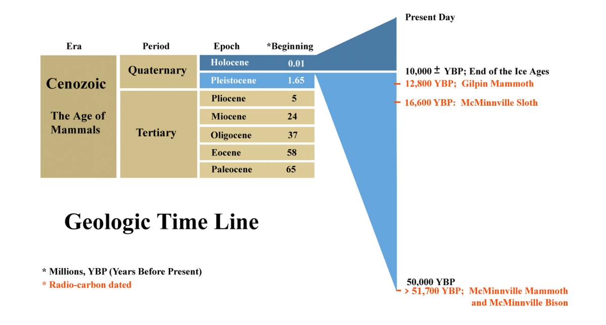
During the same blink of an eye, a new species came to dominate the land: humans. The earliest Americans left few traces of themselves as they populated the new world. Paleo-archeologists struggle to put the puzzle of the peopling of the Americas together, with many of the pieces still missing. The 50,000 years revealed to us along the banks of the Yamhill Rivers offer tantalizing clues. Paleo-archeologists study the projectile points for size, style, workmanship and material to establish approximate age, culture and purpose. Fossil bones are examined for possible taphonomic evidence indicating human modification due to predation, scavenge or use.
Geographic Scope
The Yamhill River system is composed of the South Yamhill River, North Yamhill River, and Yamhill River. With the associated streams and drainages, the resulting 25 or so miles of the Yamhill River system near McMinnville formed the primary geographic focus of this project, although we have expanded our areas of interest into the greater Willamette Valley Pleistocene and occasionally venture wherever curiosity beckons.
The South Yamhill River flows a very winding northeasterly direction in the vicinity of McMinnville. Traveling downstream to its confluence approximately 20.5 miles of the South Yamhill River has been scouted and assessed for fossils and artifacts. The river changes character greatly in this stretch, starting out shallow with a constant current flow in evidence, the bottom and associated point bars composed of fairly well sorted gravels with some sand in evidence. It then becomes a series of pools of slow current connected by stretches of shallow water, with the bottom and point bars of the shallow parts being composed of poorly sorted gravels with more sand and silt in evidence, along with some blue clay and recent muds; the bottoms of the pools consisting often of blue clay. In the lower stretches, the river becomes wider and slower, with little or no gravel in evidence, and the bottom consisting of clay, often overlain by a thin layer of silt.
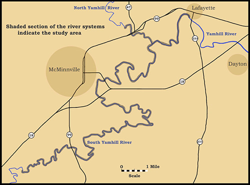
Traveling downstream to its confluence, approximately 1.8 miles of the North Yamhill have been scouted and assessed for fossils and artifacts. The North Yamhill River is considerably smaller and shallower than the South Yamhill River, and continuing upstream much farther becomes difficult due to overgrowth and obstacles. The North Yamhill River is shallow, with the bottom and attendant point bars composed mostly of poorly sorted gravels and poorly sorted sands with silt. Near the mouth, the river broadens somewhat and shallows, with the bottom predominately silted in, with a fine silty sand.
From the confluence where the North and South Yamhill Rivers form the Yamhill River, it has been floated all the way to Dayton, near its mouth at the Willamette River. However it has only been scouted and assessed for fossils as far as Lafayette, approximately 2.5 miles of river. Throughout this stretch, the river remains fairly broad, slow moving, and little if any gravel is in evidence. The bottom is characterized by the same blue clay, almost universally overlain with a layer of silty mud, depth varying with the particular river characteristics of the location.
So, the Yamhill River system is geographically broken up into three main areas of interest: the rivers themselves, searching for new sites and washed out fossils; the McMinnville Fossil Sites (Bison and Mammoth, grouped together here because of their geographic proximity) with their well preserved disarticulated mammoth skeleton and associated scattered bones of mega-fauna, rodent, mollusk and flora; and the Gilpin Fossil Site with its highly productive jumbled bone bed containing mammoth, bison and sloth. Each area of interest receives a multidisciplinary approach to its study to help us better understand the complex and diverse ecosystem of our prehistoric past.